
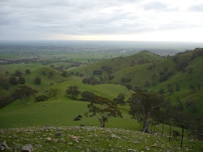
This walk starts at the entry gates to Mt Lofty Summit. The track, which is part of the Heysen Trail, is clearly identified as the Warre Track and links back to Summit Road on the other side of Mt Lofty, some 500 metres further on. Cross Summit Road, verve to your right and cross the other bitumen road marked to Cleland Conservation Park. According to the maps, Tinline Ruins should be on your left but I couldn't see this. At this point you are able to pick up a less distinct track running parallel to Summit Road into Cleland Conservation Park. Follow this until you meet Nilee Track. Walk down Nilee Track until you meet Wine Shanty Track then turn right. Follow Wine Shanty Track until you reach Yerang Track. Just before you reach the bitumen road, a less distinct track verves off to the left running parallel to Summit Road. You will soon reach Pimpala Track. It is a short uphill climb to the crest and just after the track verves to the left a less distinct track comes off on the right and descents quickly to meet Pill Box Track. At this point you have rejoined the Heysen Trail again. Follow the Heysen Trail markers until you get to Greenhill Road. Cross the road and follow the trail along the fence line. The trail verves off to the right and after a short uphill climb you arrive at the top where there is a view over Piccadilly Valley. This would be a great place to stop for a short break.
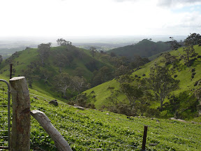
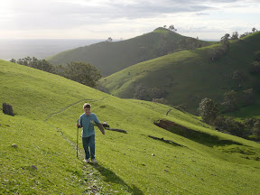
The trail runs downhill sharply here following the fence line to Ridge Road. Walk along the road verge until you reach a blue stone house. The trail continues along the verge in front of the house and then turns to the left over a stile and continues on following the fence line. It winds behind the aviation radar tower until it reconnects again with Ridge Road. There are magnificent views to your left across the city. Follow Ridge Road until you reach Coach Road which leads to the entrance to Horsnell Gully Conservation Park.
Following the trail as it winds through Horsnell Gully Conservation Park. You will need to take care that you follow the Heysen Trail markers as there are many other waking tracks in the Conservation Park. The trail eventually starts the downhill descent into the gully. Recent rains have eroded the track. You travel downhill over many loose stones for quite a distance before it crosses a small creek. You need to be sure footed here. After a short distance, the trail winds uphill for a short distance until its reaches the ruins of an old home. This was a workman's cottage for settlers who worked for Charles Giles. He was one of the area's first settlers. Another 100m on is another ruin connected with Giles - it was once home for three gardeners and their families.
From this point the trail winds steeply uphill for a good kilometre or so. It's a tough stretch so take it slowly. You will eventually arrive at the Yurrebilla Information Board at the Woodshill Road entrance to the Conservation Park. Cross the road and follow it for 50 metres where it verves off to the right through private property. Stick to the marked trail as it winds down to Lobethal Road.
The trail follows Lobethal Road for about 300m and then verves to the right. Stay close to the road railing for safety. Shortly after passing the cemetery, the trail crosses the road into Crescent Drive past the Norton Summit Primary School. On the left are views of Horsnell Gully Conservation Park and orchards. After 700m, Crescent Drive leads into the Playford Centenary Garden with its statue of Sir Thomas Playford.
Across the road is the Scenic Hotel - a great place to stop for a coffee or refreshment.

No comments:
Post a Comment